IntelliView
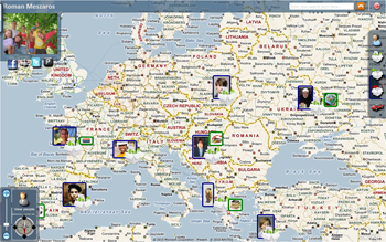
IntelliView provides set of functions, which manage visualization. Besides geocoding, that is inevitable to find specific location, main stress is laid in choosing and organizing elements on map. Due to enormous number of items to be displayed, IntelliView must choose only a subset of these items in order to maintain lucid view. To accomplish this, items are sorted by priority. Prioritisation as well as some other principles is based on most common visualization techniques that can be found in Bing Maps, Google maps, and also in well-known ESRI’s geographic information system (GIS) software products.
With list of items sorted by priority, IntelliView aims to achieve following basic goals:
- display as many information as possible,
- display items with higher priority first,
- illustrate density of items,
- maintain simplicity of view.

We try to achieve greater accuracy of displaying priority by dividing
whole viewport into grid and considering items isolated, individually
in each cell. Thus, each cell has its own representative, which is
dominating in the centre of this cell. Items in lower levels of importance
are displayed similarly as in preceding method around cell's representative.
While having improved accuracy of priority order depiction, this method
has also better performance in calculation following principles of divide and conquers.
However, in this case, location of item cannot be determined due to error
caused by centralization within cell. The goal of centralization is to avoid
collision problems on neighbouring cell's bounds. As a positive side effect,
due to uniform distribution of items on the map, this view is symmetric and more readable, too.


